Randonnée la cascade de faymont Le Val-d’Ajol Vosges
Randonnée la cascade de faymont Le Val-d’Ajol Vosges vendredi 1 mai 2026.
Randonnée la cascade de faymont Adultes A pieds Difficile
Randonnée la cascade de faymont Faymont 88340 Le Val-d’Ajol Vosges Grand Est
Durée : 180 Distance : 8700.0 Tarif :
Accès Depuis Remiremont, prendre direction Val-d’Ajol. À Faymont, avant la scierie, prendre à droite.
Parking à 100m du panneau indicateur Cascade de Faymont
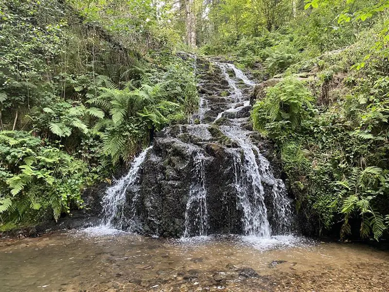
Distance 8,7km Durée 3 h Dénivelé 255 m Balisage Cercle bleu
1) Départ à pied depuis la cascade. A droite du torrent, un sentier raide mais bien tracé gagne rapidement un chemin goudronné. Le suivre jusqu’au prochain carrefour.
2) Bifurquer à droite. Un chemin forestier offre une ascension régulière à travers un bois de conifères.
3) Un aller retour de quelques dizaines de mètres permet d’accéder à la Roche Joséphine. Continuer par un chemin vers la gauche, plus étroit et au relief plus tourmenté que le précédent.
4) Une imposante fourmilière se trouvait au milieu du chemin à la création du circuit il y a 20 ans. Elle a étrangement périclité mais un autre se trouve 50m en contrebas. Juste après une ancienne ferme, virer à gauche et poursuivre jusqu’à la chapelle.
5) A la chapelle, prendre le chemin de gauche menant à une maison puis se continuant sous les frondaisons d’un petit bois. Traverser la petite route goudronnée et prendre en face la direction du Prébosson. Au centre du hameau, prendre le chemin goudronné de gauche.
6) Pénétrer à nouveau dans la forêt par un chemin de terre. Le chemin traverse une zone cultivée juste avant d’amorcer la descente après la Croix du Remoiriot.
7) Traverser un chemin goudronné pour suivre la piste forestière tirant à gauche. Elle conduit par une descente rapide à la petite route de la cascade. Remonter si nécessaire jusqu’au parking.
Difficile
https://www.tourisme-remiremont-plombieres.com/ +33 3 29 66 01 30
Afficher la carte du lieu et trouvez le meilleur itinéraire
English :
Access: From Remiremont, follow signs for Val-d?Ajol. In Faymont, before the sawmill, turn right.
Parking: 100m from the Cascade de Faymont sign
Distance: 8.7km Time: 3 h Ascent: 255 m Signs: Blue circle
1) Start on foot from the waterfall. To the right of the torrent, a steep but well-marked path soon leads to a tarmac road. Follow it to the next crossroads.
2) Turn right. A forest track offers a steady ascent through a coniferous wood.
3) After a few dozen meters, you reach Roche Joséphine. Continue along a path to the left, narrower and more rugged than the previous one.
4) An imposing anthill stood in the middle of the path when the circuit was created 20 years ago. Strangely enough, it has now disappeared, but there’s another one 50m below. Just past an old farmhouse, turn left and continue to the chapel.
5) At the chapel, take the left-hand path leading to a house, then continuing under the foliage of a small wood. Cross the small asphalt road and head straight ahead towards Prébosson. In the center of the hamlet, take the left-hand asphalt track.
6) Re-enter the forest on a dirt track. The path crosses a cultivated area just before starting the descent past the Croix du Remoiriot.
7) Cross a tarmac road and follow the forest track to the left. This leads steeply downhill to the small waterfall road. If necessary, climb back up to the parking lot.
Deutsch :
Zugang: Von Remiremont aus Richtung Val-d?Ajol fahren. In Faymont, vor dem Sägewerk, rechts abbiegen.
Parkplatz: 100 m vom Hinweisschild Cascade de Faymont entfernt
Entfernung: 8,7km Dauer: 3 h Höhenunterschied: 255 m Markierung: Blauer Kreis
1) Start zu Fuß vom Wasserfall aus. Auf der rechten Seite des Wildbachs führt ein steiler, aber gut ausgebauter Pfad bald auf einen asphaltierten Weg. Folgen Sie dem Weg bis zur nächsten Kreuzung.
2) Biegen Sie rechts ab. Ein Waldweg bietet einen gleichmäßigen Anstieg durch einen Nadelwald.
3) Ein paar Dutzend Meter hin und zurück bringen Sie zum Roche Joséphine. Weiter geht es auf einem Weg nach links, der schmaler ist und dessen Relief stärker geprägt ist als der vorherige.
4) Als der Rundweg vor 20 Jahren angelegt wurde, befand sich mitten auf dem Weg ein imposanter Ameisenhaufen. Er ist seltsamerweise eingegangen, aber ein weiterer befindet sich 50 m unterhalb des Weges. Gleich nach einem alten Bauernhof biegen Sie links ab und gehen weiter bis zur Kapelle.
5) An der Kapelle nehmen Sie den linken Weg, der zu einem Haus führt und dann unter dem Laubdach eines kleinen Waldes weitergeht. Überqueren Sie die kleine asphaltierte Straße und gehen Sie gegenüber in Richtung Prébosson. In der Mitte des Weilers nehmen Sie den linken asphaltierten Weg.
6) Gehen Sie auf einem Feldweg wieder in den Wald hinein. Der Weg durchquert ein landwirtschaftlich genutztes Gebiet, kurz bevor es nach dem Croix du Remoiriot bergab geht.
7) Überqueren Sie einen asphaltierten Weg und folgen Sie dem links abzweigenden Waldweg. Er führt über einen schnellen Abstieg zur kleinen Straße zum Wasserfall. Steigen Sie gegebenenfalls bis zum Parkplatz auf.
Italiano :
Accesso: Da Remiremont, direzione Val-d’Ajol. A Faymont, prima della segheria, girare a destra.
Parcheggio: a 100 m dal cartello Cascade de Faymont
Distanza: 8,7 km Tempo: 3 h Dislivello: 255 m Segnalazione: cerchio blu
1) Partenza a piedi dalla cascata. A destra del torrente, un sentiero ripido ma ben segnalato conduce rapidamente a una strada asfaltata. Seguirla fino all’incrocio successivo.
2) Girare a destra. Una pista forestale conduce in costante salita attraverso un bosco di conifere.
3) Dopo poche decine di metri si raggiunge la Roche Joséphine. Si prosegue su un sentiero a sinistra, più stretto e accidentato del precedente.
4) Un imponente formicaio si trovava al centro del sentiero quando questo fu realizzato 20 anni fa. Stranamente è caduto in rovina, ma ce n’è un altro 50 m più in basso. Subito dopo una vecchia casa colonica, si gira a sinistra e si prosegue fino alla cappella.
5) Alla cappella, prendere il sentiero di sinistra che porta a una casa, quindi proseguire sotto il fogliame di un piccolo bosco. Attraversare la stradina asfaltata e dirigersi di fronte verso Prébosson. Nel centro della frazione, prendere il sentiero asfaltato a sinistra.
6) Tornare nel bosco su una strada sterrata. La pista attraversa un’area coltivata poco prima di iniziare la discesa, passando per la croce di Remoiriot.
7) Attraversare una pista asfaltata e seguire la pista forestale a sinistra. Questa conduce rapidamente in discesa alla stradina che porta alla cascata. Se necessario, risalire fino al parcheggio.
Español :
Acceso: Desde Remiremont, dirigirse hacia Val-d’Ajol. En Faymont, antes del aserradero, girar a la derecha.
Aparcamiento: a 100 m de la señal Cascade de Faymont
Distancia: 8,7 km Tiempo: 3 h Desnivel: 255 m Señalización: Círculo azul
1) Empezar a pie desde la cascada. A la derecha del torrente, un sendero empinado pero bien señalizado desemboca rápidamente en una carretera asfaltada. Sígala hasta el siguiente cruce.
2) Gire a la derecha. Una pista forestal asciende a través de un bosque de coníferas.
3) Tras unas decenas de metros, llegará a Roche Joséphine. Continúe por un camino a la izquierda, más estrecho y accidentado que el anterior.
4) Un imponente hormiguero se erguía en medio del sendero cuando éste se creó hace 20 años. Extrañamente se ha deteriorado, pero hay otro 50 m más abajo. Justo después de una antigua granja, gire a la izquierda y continúe hasta la capilla.
5) En la capilla, tome el camino de la izquierda que conduce a una casa, luego continúe bajo el follaje de un pequeño bosque. Cruzar la pequeña carretera asfaltada y seguir en dirección opuesta hacia Prébosson. En el centro de la aldea, tomar la pista asfaltada de la izquierda.
6) Volver al bosque por una pista de tierra. La pista atraviesa una zona cultivada justo antes de empezar a descender pasando por la cruz de Remoiriot.
7) Cruzar una pista asfaltada y seguir la pista forestal a la izquierda. Esta pista desciende rápidamente hasta el pequeño camino de la cascada. Si es necesario, vuelva a subir hasta el aparcamiento.
Cet itinéraire a été mise à jour le 2025-01-30 par Système d’information touristique Lorrain
À voir aussi à Le Val-d'Ajol (Vosges)
- Atelier poterie salle des Epinettes Le Val-d’Ajol 23 avril 2026
- Tritons, les dragons de la mare Lieu-dit Le Breuil, forêt d’Hérival Le Val-d’Ajol 25 avril 2026
- Randonnée les feuillées Le Val-d’Ajol Vosges 1 mai 2026
- Randonnée outremont et la croix de jaranceau Le Val-d’Ajol Vosges 1 mai 2026
- Randonnée la forêt du chanot Le Val-d’Ajol Vosges 1 mai 2026