Randonnée la forêt du chanot Le Val-d’Ajol Vosges
Randonnée la forêt du chanot Le Val-d’Ajol Vosges vendredi 1 mai 2026.
Randonnée la forêt du chanot Adultes A pieds Facile
Randonnée la forêt du chanot lieu-dit Hôtel Enfoncé 88340 Le Val-d’Ajol Vosges Grand Est
Durée : 120 Distance : 6000.0 Tarif :
Accès Depuis Remiremont, prendre la voie rapide direction Vesoul. Prendre la sortie D20 Le Val-d’Ajol, puis direction la Croisette aux ronds-points.
Parking se stationner au lieu-dit l’Hôtel Enfoncé.
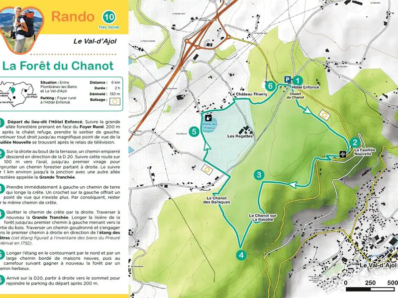
Distance 6 km Durée 2 h Dénivelé 130m Balisage anneau jaune.
1) Départ du lieu-dit l’Hôtel Enfoncé. Suivre la grande allée forestière prenant en face du Foyer Rural. 200 m après le chalet refuge, prendre le sentier de gauche. Continuer tout droit jusqu’au magnifique point de vue de la Feuillée Nouvelle se trouvant après le relais de télévision.
2) Sur la droite au bout de la terrasse, un chemin empierré descend en direction de la D 20. Suivre cette route sur 100 m vers l’aval, jusqu’au premier virage pour emprunter un chemin forestier partant à droite. Le suivre sur 1 km environ jusqu’à la jonction avec une autre allée forestière appelée la Grande Tranchée.
3) Prendre immédiatement à gauche un chemin de terre qui longe la crête. Un crochet sur la gauche offrait un point de vue qui n’existe plus. Par conséquent, rester sur le même chemin de crête.
4) Quitter le chemin de crête par la droite. Traverser à nouveau la Grande Tranchée. Longer la lisière de la forêt jusqu’au premier chemin à gauche menant vers la sortie du bois. Traverser un chemin goudronné et s’engager dans le premier chemin à droite en direction de l’étang des Prêtres (cet étang figurait à l’inventaire des biens du Prieuré d’Hérival en 1792).
5) Longer l’étang en le contournant par le nord et par un large chemin bordé de maisons neuves, puis au carrefour suivant gagner à nouveau la forêt par un chemin herbeux.
6) Arrivé sur la D20, partir à droite vers le sommet pour rejoindre le parking du départ après 200 m.
Facile
+33 3 29 62 23 70
Afficher la carte du lieu et trouvez le meilleur itinéraire
English :
Access From Remiremont, take the highway to Vesoul. Take the exit D20 Le Val-d’Ajol, then direction La Croisette at the traffic circles.
Parking park at the place called l’Hôtel Enfoncé
Distance 6 km Duration 2 h Difference in height 130m Marking yellow ring
1) Departure from the place called l’Hôtel Enfoncé. Follow the large forest path in front of the Foyer Rural. 200 m after the chalet refuge, take the left path. Continue straight ahead until you reach the magnificent viewpoint of La Feuillée Nouvelle, which is located after the television relay station.
2) On the right, at the end of the terrace, a gravel road goes down towards the D 20. Follow this road for 100 m downstream, until the first bend in the road where you will find a forestry road on the right. Follow it for about 1 km until the junction with another forest path called the Grande Tranchée.
3) Immediately turn left onto a dirt road that runs along the ridge. A hook on the left offered a viewpoint that no longer exists. Therefore, stay on the same ridge path.
4) Leave the ridge path on the right. Cross the Grande Tranchée again. Follow the edge of the forest to the first path on the left leading out of the woods. Cross a paved road and take the first path on the right towards the pond of the Priests (this pond was listed in the inventory of the property of the Priory of Hérival in 1792).
5) Go along the pond, bypassing it by the north and by a wide road lined with new houses, then at the next crossroads go back to the forest by a grassy path.
6) Once on the D20, go to the right towards the summit to join the parking lot after 200 m.
Deutsch :
Anfahrt: Von Remiremont aus nehmen Sie die Schnellstraße in Richtung Vesoul. Nehmen Sie die Ausfahrt D20 Le Val-d’Ajol, dann an den Kreisverkehren Richtung La Croisette.
Parken: Parken Sie am Ort l’Hôtel Enfoncé
Entfernung: 6 km Dauer: 2 h Höhenunterschied: 130 m Markierung: gelber Ring
1) Start am Ort l’Hôtel Enfoncé . Folgen Sie der großen Waldallee, die gegenüber dem Foyer Rural abzweigt. 200 m nach dem Chalet refuge nehmen Sie den linken Weg. Gehen Sie geradeaus bis zum wunderschönen Aussichtspunkt Feuillée Nouvelle, der sich hinter dem Fernsehrelais befindet.
2) Auf der rechten Seite am Ende der Terrasse führt ein geschotterter Weg hinunter zur D20. Folgen Sie dieser Straße 100 m flussabwärts, bis Sie an der ersten Kurve einen rechts abzweigenden Waldweg nehmen. Folgen Sie ihm etwa 1 km bis zur Kreuzung mit einem anderen Waldweg, der als Grande Tranchée bezeichnet wird.
3) Biegen Sie sofort links auf einen Feldweg ab, der am Kamm entlang führt. Ein Haken auf der linken Seite bot einen Aussichtspunkt, der nicht mehr existiert. Bleiben Sie daher auf demselben Kammweg.
4) Verlassen Sie den Kammweg nach rechts. Überqueren Sie erneut den Großen Graben. Gehen Sie am Waldrand entlang bis zum ersten Weg links, der zum Ausgang des Waldes führt. Überqueren Sie einen asphaltierten Weg und biegen Sie in den ersten Weg rechts in Richtung Étang des Prêtres ein (dieser Teich war 1792 im Inventar der Güter des Priorats von Hérival aufgeführt).
5) Gehen Sie nördlich um den Teich herum auf einem breiten, von neuen Häusern gesäumten Weg und an der nächsten Kreuzung auf einem grasbewachsenen Weg wieder in den Wald.
6) Auf der D20 angekommen, gehen Sie rechts in Richtung Gipfel und erreichen nach 200 m den Parkplatz des Starts.
Italiano :
Accesso: Da Remiremont, prendere la superstrada in direzione di Vesoul. Prendere l’uscita D20 per Le Val-d’Ajol, quindi dirigersi verso La Croisette alle rotonde.
Parcheggio: parcheggiare al posto chiamato l’Hôtel Enfoncé
Distanza: 6 km Durata: 2 h Dislivello: 130 m Segnaletica: anello giallo
1) Partite dal luogo chiamato l’Hôtel Enfoncé. Seguire l’ampio sentiero forestale di fronte al Foyer Rural. 200 m dopo lo chalet del rifugio, prendere il sentiero di sinistra. Proseguite dritti fino a raggiungere il magnifico punto panoramico di La Feuillée Nouvelle, che si trova dopo la stazione di trasmissione televisiva.
2) Alla fine della terrazza, sulla destra, un sentiero di ghiaia conduce al D20. Seguire questa strada per 100 m a valle, fino alla prima curva della strada, dove si imbocca una pista forestale a destra. Seguitelo per circa 1 km fino a quando si unisce a un’altra strada forestale chiamata Grande Tranchée.
3) Svoltate subito a sinistra su un sentiero sterrato che costeggia il crinale. Un gancio a sinistra offriva un punto di vista che non esiste più. Rimanete quindi sullo stesso sentiero di cresta.
4) Lasciare il sentiero di cresta sulla destra. Riattraversare la Grande Tranchée. Seguite il margine del bosco fino al primo sentiero a sinistra che esce dal bosco. Attraversate una pista asfaltata e prendete il primo sentiero a destra verso l’Etang des Prêtres (questo stagno è stato inserito nell’inventario del Priorato di Hérival nel 1792).
5) Costeggiare lo stagno, aggirandolo da nord e imboccando un ampio sentiero fiancheggiato da nuove case, quindi al successivo incrocio tornare al bosco su un sentiero erboso.
6) Una volta imboccata la D20, svoltate a destra verso la vetta per raggiungere il parcheggio dopo 200 m.
Español :
Acceso: Desde Remiremont, tomar la autopista en dirección a Vesoul. Tome la salida de la D20 en dirección a Le Val-d’Ajol, luego diríjase a La Croisette en las rotondas.
Aparcamiento: aparcar en el lugar llamado l’Hôtel Enfoncé
Distancia: 6 km Duración: 2 h Desnivel: 130m Señalización: anillo amarillo
1) Empezar desde el lugar llamado l’Hôtel Enfoncé. Siga el gran camino del bosque frente al Foyer Rural. 200 m después del chalet refugio, tomar el camino de la izquierda. Siga recto hasta llegar al magnífico mirador de La Feuillée Nouvelle, que se encuentra después de la estación de retransmisión de televisión.
2) A la derecha, al final de la terraza, un camino de grava baja hasta el D20. Siga esta carretera durante 100 m río abajo, hasta la primera curva de la carretera donde se toma una pista forestal a la derecha. Sígala durante aproximadamente 1 km hasta que se une a otro camino forestal llamado Grande Tranchée.
3) Inmediatamente, gire a la izquierda por una pista de tierra que recorre la cresta. Un gancho a la izquierda ofrecía un punto de vista que ya no existe. Por lo tanto, manténgase en el mismo camino de la cresta.
4) Dejar el camino de la cresta a la derecha. Vuelva a cruzar la Grande Tranchée. Siga el borde del bosque hasta el primer camino a la izquierda que sale del bosque. Atravesar una pista asfaltada y tomar el primer camino a la derecha hacia el Etang des Prêtres (este estanque figuraba en el inventario del Priorato de Hérival en 1792).
5) Bordear el estanque, rodeándolo por el norte y tomando un camino ancho bordeado de casas nuevas, luego en el siguiente cruce volver al bosque por un camino de hierba.
6) Una vez en la D20, gire a la derecha hacia la cumbre para llegar al aparcamiento después de 200 m.
Cet itinéraire a été mise à jour le 2025-01-30 par Système d’information touristique Lorrain
À voir aussi à Le Val-d'Ajol (Vosges)
- Atelier poterie salle des Epinettes Le Val-d’Ajol 23 avril 2026
- Tritons, les dragons de la mare Lieu-dit Le Breuil, forêt d’Hérival Le Val-d’Ajol 25 avril 2026
- Randonnée la cascade de faymont Le Val-d’Ajol Vosges 1 mai 2026
- Randonnée les feuillées Le Val-d’Ajol Vosges 1 mai 2026
- Randonnée outremont et la croix de jaranceau Le Val-d’Ajol Vosges 1 mai 2026