Circuit tour du lac de Bouzey Sanchey Vosges
Circuit tour du lac de Bouzey Sanchey Vosges vendredi 1 mai 2026.
Circuit tour du lac de Bouzey Adultes En VTT Facile
Itinéraire de promenade et de randonnée, PR Circuit tour du lac de Bouzey Camping à la ferme 88390 Sanchey Vosges Grand Est
Durée : 120 Distance : 7000.0 Tarif :
Merci au club vosgien pour la réalisation de cette randonnée et du travail fait par ses équipes tout au long de l’année pour baliser et entretenir ces chemins.
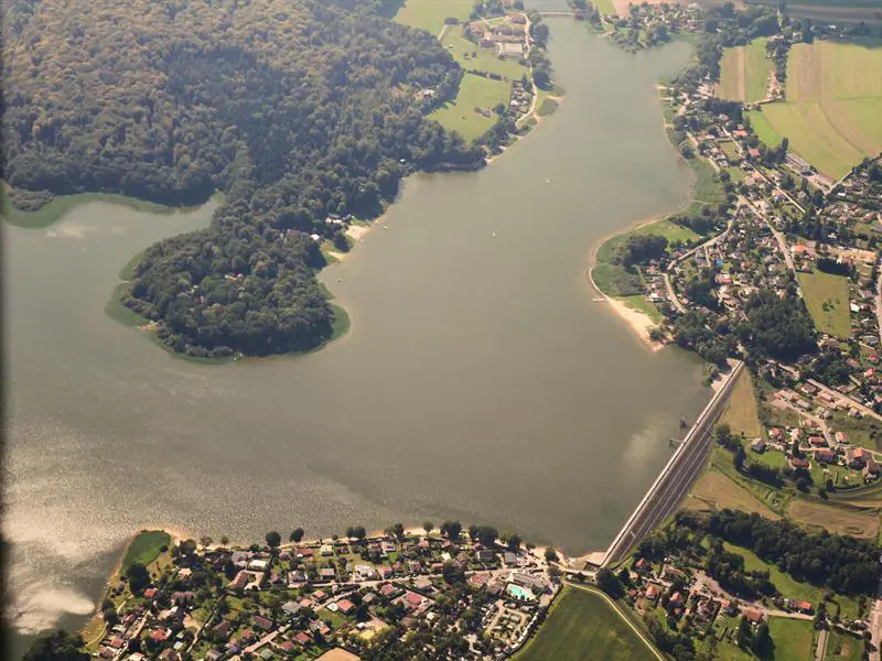
Une belle balade sans difficulté qui vous fera faire le tour du lac.
Balisage: anneau bleu 7km
Prendre le sentier empierré qui longe le parking en direction de la forêt. A la lisière tourner à droite, puis immédiatement à gauche pour suivre le cheminement balisé (croix de couleur bleue) qui emprunte la digue de l’étang, à l’extrémité de laquelle le conservatoire des Sites Lorrains a installé un panneau d’information. Prendre le temps de parcourir le sentier pédagogique à la découverte des milieux, de la faune et de la flore de cet étang.
Au sortir de la digue, prendre à droite le chemin balisé (disque plein de couleur rouge) et (croix de couleur bleue) pour déboucher sur un chemin empierré qui vous conduit tout droit sur la rive du lac de Bouzey. Au sortir de la forêt, après être passé devant un panneau d’information, traverser la route goudronnée, suivre à droite le sentier balisé (disque de couleur bleu) et (disque plein de couleur vert) longeant le lac, passer sur la digue, prendre à gauche la route goudronnée entre les habitations. Continuer sur cette petite route qui longe le lac sans se soucier des rues qui partent à droite. En suivant toujours le balisage (disque de couleur bleu), vous passez sur un pont qui franchit le bout du lac. La route goudronnée prend, en montant, la direction de la forêt.
Arrivé au dessus la côte, vous la quittez pour prendre à droite devant vous un chemin de terre balisé (disque de couleur bleu) et (disque plein de couleur bleu) qui traverse la forêt sur 1,3 km. Le cheminement balisé (disque de couleur bleu) vous conduit en longeant le lac au point de départ. En suivant droit devant vous la route qui monte, vous rejoignez le parking au départ de la balade.
Balisage: anneau bleu
Facile
https://www.tourisme-epinal.com/sejourner/nos-circuits/circuit-du-tour-du-lac-de-bouzey-501949 +33 3 29 82 53 32
Afficher la carte du lieu et trouvez le meilleur itinéraire
English :
Thank you to the Vosges club for the realization of this hike and the work done by its teams throughout the year to mark out and maintain these paths.
A beautiful walk without difficulty that will take you around the lake.
Beaconing: blue ring 7km
Take the stony path along the parking lot towards the forest. At the edge turn right, then immediately left to follow the marked path (blue cross) which follows the pond dike, at the end of which the Conservatoire des Sites Lorrains has installed an information board. Take the time to walk along the educational trail to discover the environment, fauna and flora of this pond.
At the end of the dike, turn right on the marked path (red disc) and (blue cross) to come out on a stony path that leads you straight on the shore of the lake of Bouzey. At the end of the forest, after passing an information board, cross the asphalt road, follow the marked path (blue disc) and (green disc) on the right along the lake, pass the dike, take the asphalt road between the houses on the left. Continue on this small road that runs along the lake without worrying about the streets that go to the right. Always following the beaconing (blue disc), you pass on a bridge which crosses the end of the lake. The asphalt road takes, while going up, the direction of the forest.
Arrived at the top of the coast, you leave it to take on the right in front of you a marked out dirt track (blue disc) and (blue disc full) which crosses the forest on 1,3 km. The marked path (blue disc) leads you along the lake to the starting point. Following the road straight ahead, you will reach the car park at the start of the walk
Beaconing: blue ring
Deutsch :
Vielen Dank an den Club Vosgien für die Durchführung dieser Wanderung und die Arbeit, die seine Teams das ganze Jahr über leisten, um diese Wege zu markieren und instand zu halten.
Eine schöne Wanderung ohne Schwierigkeiten, die Sie rund um den See führt.
Markierung: Blauer Ring 7km
Nehmen Sie den geschotterten Weg, der am Parkplatz vorbei in Richtung Wald führt. Am Waldrand biegen Sie rechts ab, dann gleich wieder links, um dem markierten Weg (blaues Kreuz) zu folgen, der über den Damm des Teichs führt, an dessen Ende das Conservatoire des Sites Lorrains eine Informationstafel aufgestellt hat. Nehmen Sie sich die Zeit, den Lehrpfad zu durchlaufen, um die Lebensräume, die Fauna und die Flora dieses Teichs zu entdecken.
Wenn Sie den Damm verlassen, nehmen Sie rechts den markierten Weg (rote Scheibe) und (blaues Kreuz), um auf einen Schotterweg zu gelangen, der Sie geradewegs an das Ufer des Sees von Bouzey führt. Wenn Sie den Wald verlassen und an einem Informationsschild vorbeikommen, überqueren Sie die asphaltierte Straße, folgen rechts dem markierten Weg (blaue Scheibe) und (grüne Scheibe) entlang des Sees, überqueren den Damm und biegen links auf die asphaltierte Straße zwischen den Häusern ab. Gehen Sie auf dieser kleinen Straße am See entlang weiter, ohne auf die Straßen zu achten, die nach rechts abgehen. Folgen Sie immer der Markierung (blaue Scheibe) und überqueren Sie eine Brücke, die über das Ende des Sees führt. Die asphaltierte Straße führt bergauf in Richtung Wald.
Wenn Sie die Küste überqueren, verlassen Sie sie und nehmen rechts vor Ihnen einen markierten Feldweg (blaue Scheibe) und (volle blaue Scheibe), der 1,3 km lang durch den Wald führt. Der markierte Weg (blaue Scheibe) führt Sie am See entlang zurück zum Ausgangspunkt. Wenn Sie der ansteigenden Straße geradeaus folgen, erreichen Sie den Parkplatz am Ausgangspunkt der Wanderung
Markierung: blauer Ring
Italiano :
Si ringrazia il Club dei Vosgi per la realizzazione di questa escursione e per il lavoro svolto dalle sue squadre durante tutto l’anno per tracciare e mantenere questi sentieri.
Una bella passeggiata senza difficoltà che vi farà fare il giro del lago.
Marcatura: anello blu 7 km
Prendere il sentiero di ghiaia che costeggia il parcheggio in direzione del bosco. Al limite del bosco, svoltare a destra e poi subito a sinistra per seguire il sentiero segnalato (croce blu) che segue l’argine del lago, alla fine del quale il Conservatoire des Sites Lorrains ha installato un pannello informativo. Prendetevi il tempo di camminare lungo il sentiero didattico per scoprire l’ambiente, la fauna e la flora di questo stagno.
Alla fine della diga, svoltate a destra sul sentiero segnalato (disco rosso pieno) e (croce blu) per raggiungere un sentiero di ghiaia che vi porta direttamente alla riva del lago Bouzey. Alla fine del bosco, dopo aver superato un pannello informativo, attraversare la strada asfaltata, seguire a destra il sentiero segnalato (disco blu) e (disco solido verde) lungo il lago, passare sulla diga, prendere a sinistra la strada asfaltata tra le case. Proseguite lungo questa stradina che costeggia il lago senza preoccuparvi delle strade che si allontanano sulla destra. Seguendo sempre le indicazioni (disco blu), si passa su un ponte che attraversa la fine del lago. La strada asfaltata sale verso la foresta.
Arrivati in cima alla collina, si lascia la strada e si gira a destra su un sentiero sterrato segnalato (disco blu) e (disco blu pieno) che attraversa il bosco per 1,3 km. Il sentiero segnalato (disco blu) vi conduce lungo il lago fino al punto di partenza. Seguendo la strada dritta, si raggiunge il parcheggio all’inizio della passeggiata
Marcatura: anello blu
Español :
Gracias al Club de los Vosgos por la realización de esta excursión y por el trabajo realizado por sus equipos a lo largo del año para delimitar y mantener estos senderos.
Un bonito paseo sin dificultad que te hará dar la vuelta al lago.
Señalización: anillo azul 7km
Tome el camino de grava que bordea el aparcamiento en dirección al bosque. En el límite del bosque, gire a la derecha y, enseguida, a la izquierda para seguir el sendero marcado (cruz azul) que sigue el dique del lago, al final del cual el Conservatoire des Sites Lorrains ha instalado un panel informativo. Tómese el tiempo de recorrer el sendero educativo para descubrir el entorno, la fauna y la flora de este estanque.
Al final de la presa, gire a la derecha en el camino marcado (disco sólido rojo) y (cruz azul) para llegar a un camino de grava que le lleva directamente a la orilla del lago Bouzey. Al final del bosque, después de pasar un panel informativo, cruzar la carretera asfaltada, seguir a la derecha el camino marcado (disco azul) y (disco sólido verde) a lo largo del lago, pasar por la presa, tomar a la izquierda el camino asfaltado entre las casas. Continúe por esta pequeña carretera que bordea el lago sin preocuparse de las calles que salen a la derecha. Siguiendo siempre las señales (disco azul), se pasa por un puente que cruza el final del lago. La carretera asfaltada sube hacia el bosque.
Al llegar a la cima de la colina, se deja la carretera y se gira a la derecha por una pista de tierra marcada (disco azul) y (disco azul sólido) que atraviesa el bosque durante 1,3 km. El camino marcado (disco azul) le lleva a lo largo del lago hasta el punto de partida. Siguiendo la carretera todo recto, se llega al aparcamiento del inicio del paseo
Marcado: anillo azul
Cet itinéraire a été mise à jour le 2025-03-27 par Système d’information touristique Lorrain