Circuit trail 8 Le Ballon d’Alsace Saint-Maurice-sur-Moselle Vosges
Circuit trail 8 Le Ballon d’Alsace Saint-Maurice-sur-Moselle Vosges vendredi 1 mai 2026.
Circuit trail 8 Le Ballon d’Alsace Adultes Trail Difficile
Circuit trail 8 Le Ballon d’Alsace 28bis rue de Lorraine 88560 Saint-Maurice-sur-Moselle Vosges Grand Est
Durée : Distance : 16280.001 Tarif :
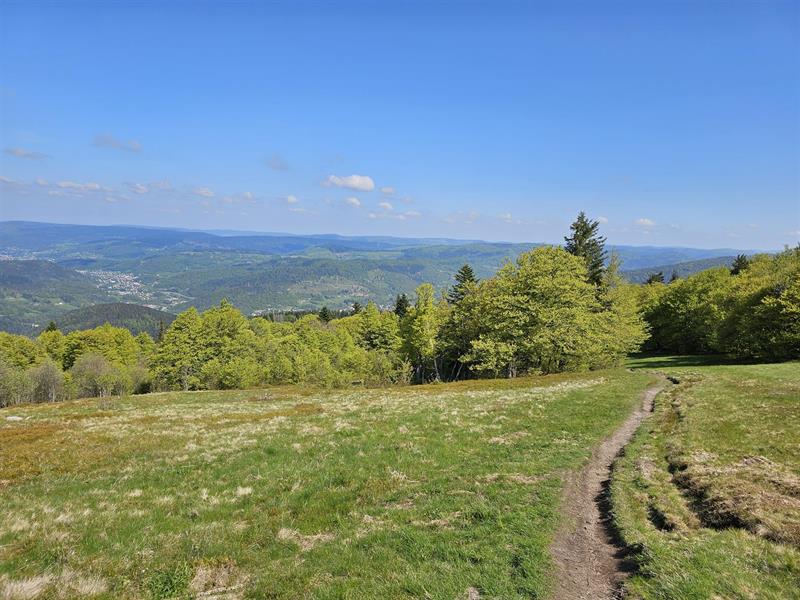
Distance 16.28 km Dénivelé 900 m Durée 2h10 à 4h20 Balisage Trail n° 8 rouge + Club Vosgien Niveau Difficile. Départ Parking de l’Office de tourisme. Un superbe parcours au départ de Saint-Maurice-sur-Moselle, parfait pour découvrir et gravir le mythique Ballon d’Alsace. L’ascension est exigeante mais très agréable, alternant sections forestières ombragées et portions dégagées offrant de superbes panoramas pour arriver à la Statue de Jeanne d’Arc. Une fois au sommet, la vue s’étend des plaines alsaciennes jusqu’au Mont-Blanc par temps clair. La descente se fait par le même chemin avant de rejoindre de larges pistes forestières en passant par le chalet Spiller en direction de la Goutte du Rieux. Un dernier effort sur une belle piste avant de redescendre vers le centre du village, point de départ de cette boucle. Un excellent itinéraire pour effectuer une sortie avec dénivelé tout en découvrant les paysages exceptionnels des Ballons des Hautes-Vosges. Les parcours dans votre smartphone… Retrouvez tous les parcours de l’Espace Trail des Ballons des Vosges gratuitement dans votre smartphone grâce à l’application Trail Connect, dans la rubrique Destinations à découvrir . Traces Gpx et Pdf de la sortie sont téléchargeables ci-dessous.
Difficile
https://espacestrail.run/ballonsdesvosges
Afficher la carte du lieu et trouvez le meilleur itinéraire
English :
Distance: 16.28 km Difference in altitude: 900 m Duration: 2h10 to 4h20 Trail markings no. 8 red + Club Vosgien Difficulty level. Start: Tourist Office parking lot. A superb trail from Saint-Maurice-sur-Moselle, perfect for discovering and climbing the mythical Ballon d’Alsace. The ascent is demanding but highly enjoyable, alternating between shady forest sections and open stretches offering superb panoramic views to reach the Joan of Arc Statue. Once at the summit, the view stretches from the Alsatian plains to Mont-Blanc on a clear day. The descent is made along the same path before joining wide forest tracks past the Chalet Spiller towards the Goutte du Rieux. A final effort on a fine trail before heading back down to the village center, the starting point of this loop. An excellent route for an outing with a difference in altitude, while discovering the exceptional landscapes of the Ballons des Hautes-Vosges. The routes on your smartphone… Find all the trails of the Espace Trail des Ballons des Vosges free of charge on your smartphone thanks to the Trail Connect application, in the Destinations to discover section. Gpx tracks and Pdf of the outing can be downloaded below.
Deutsch :
Distanz: 16.28 km Höhenunterschied: 900 m Dauer: 2h10 bis 4h20 Markierung Trail n° 8 rot + Club Vosgien Niveau: Schwierig. Start: Parkplatz des Fremdenverkehrsamtes. Eine wunderschöne Strecke ab Saint-Maurice-sur-Moselle, perfekt um den mythischen Ballon d’Alsace zu entdecken und zu besteigen. Der Aufstieg ist anspruchsvoll, aber sehr angenehm. Es wechseln sich schattige Waldabschnitte und offene Abschnitte mit herrlichen Panoramen ab, bis Sie die Statue von Jeanne d’Arc erreichen. Auf dem Gipfel angekommen, reicht der Blick von den elsässischen Ebenen bis zum Mont-Blanc an klaren Tagen. Der Abstieg erfolgt auf demselben Weg, bevor Sie auf breiten Waldpisten an der Hütte Spiller vorbei in Richtung Goutte du Rieux wandern. Eine letzte Anstrengung auf einer schönen Piste, bevor es wieder hinunter zum Dorfzentrum geht, dem Ausgangspunkt dieser Rundwanderung. Eine ausgezeichnete Route, um einen Ausflug mit Höhenunterschied zu machen und dabei die außergewöhnlichen Landschaften der Ballons des Hautes-Vosges zu entdecken. Die Strecken in Ihrem Smartphone… Finden Sie alle Strecken des Espace Trail des Ballons des Vosges kostenlos in Ihrem Smartphone mit der App Trail Connect in der Rubrik Destinations à découvrir (Ziele, die es zu entdecken gilt). Gpx- und Pdf-Tracks der Ausflüge können Sie unten herunterladen.
Italiano :
Distanza: 16,28 km Dislivello: 900 m Durata: da 2h10 a 4h20 Segnavia n. 8 rosso + Club Vosgien Livello difficile. Partenza: parcheggio dell’Ufficio del Turismo. Un superbo percorso da Saint-Maurice-sur-Moselle, perfetto per scoprire e scalare il mitico Ballon d’Alsace. L’ascesa è impegnativa ma molto piacevole, alternando tratti di bosco ombroso a tratti aperti che offrono superbe viste panoramiche fino a raggiungere la Statua di Giovanna d’Arco. Una volta in cima, la vista spazia dalle pianure dell’Alsazia al Monte Bianco nelle giornate limpide. La discesa segue lo stesso percorso prima di immettersi su ampie piste forestali, passando davanti allo Chalet Spiller, verso la Goutte du Rieux. Un ultimo sforzo su un bel sentiero prima di ridiscendere verso il centro del paese, punto di partenza di questo anello. Si tratta di un ottimo percorso per una gita con dislivello, alla scoperta degli eccezionali paesaggi dei Ballons des Hautes-Vosges. I percorsi sul vostro smartphone… Tutti i percorsi dell’Espace Trail des Ballons des Vosges sono disponibili gratuitamente sul vostro smartphone grazie all’applicazione Trail Connect, nella sezione Destinazioni da scoprire . Le tracce Gpx e i Pdf dell’escursione possono essere scaricati qui sotto.
Español :
Distancia: 16,28 km Desnivel: 900 m Duración: 2h10 a 4h20 Sendero señalizado n° 8 rojo + Club Vosgien Nivel difícil. Salida: Aparcamiento de la Oficina de Turismo. Un magnífico sendero desde Saint-Maurice-sur-Moselle, perfecto para descubrir y escalar el mítico Ballon d’Alsace. La ascensión es exigente pero muy agradable, alternando tramos de bosque sombrío y tramos abiertos que ofrecen magníficas vistas panorámicas hasta llegar a la estatua de Juana de Arco. Una vez en la cima, la vista se extiende desde las llanuras de Alsacia hasta el Mont Blanc en un día despejado. El descenso sigue el mismo itinerario antes de entrar en amplias pistas forestales, pasando por el Chalet Spiller, en dirección a la Goutte du Rieux. Un último esfuerzo por una buena pista antes de bajar de nuevo al centro del pueblo, punto de partida de este bucle. Se trata de un excelente itinerario para una salida con desnivel, descubriendo al mismo tiempo los excepcionales paisajes de los Ballons des Hautes-Vosges. Los itinerarios en su smartphone… Puede encontrar gratuitamente en su smartphone todos los itinerarios del Espace Trail des Ballons des Vosges gracias a la aplicación Trail Connect, en la sección Destinos por descubrir . A continuación podrá descargar los tracks Gpx y el Pdf de la salida.
Cet itinéraire a été mise à jour le 2026-05-12 par Système d’information touristique Lorrain