Randonnée les fontaines du ban d’ajol Plombières-les-Bains Vosges
Randonnée les fontaines du ban d’ajol Plombières-les-Bains Vosges vendredi 1 mai 2026.
Randonnée les fontaines du ban d’ajol Adultes A pieds Facile
Randonnée les fontaines du ban d’ajol Promenade des Dames 88370 Plombières-les-Bains Vosges Grand Est
Durée : 75 Distance : 3000.0 Tarif :
Accès Depuis Remiremont, aller à Plombières-les-Bains.
Parking Se garer sur la Promenade des Dames.
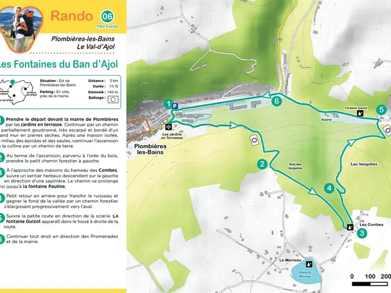
Distance 3 km Durée 1 h 15 Dénivelé 140m Balisage anneau bleu.
1) Prendre le départ devant la mairie de Plombières par les jardins en terrasse. Continuer par un chemin partiellement goudronné, très escarpé et bordé d’un grand mur en pierres sèches. Après une maison isolée, au milieu des épicéas et des saules, continuer l’ascension de la colline par un chemin de terre.
2) Au terme de l’ascension, parvenu à l’orée du bois, prendre le petit chemin forestier à gauche.
3) À l’approche des maisons du hameau des Combes, suivre un sentier herbeux descendant sur la gauche en direction d’une sapinière. Le chemin se prolonge ainsi jusqu’à la fontaine Pauline.
4) Petit retour en arrière pour franchir le ruisseau et gagner le fond de la vallée par un chemin forestier s’élargissant progressivement vers l’aval.
5) Suivre la petite route en direction de la scierie. La fontaine Guizot apparaît dans le fossé à droite de la route.
6) Continuer tout droit en direction des Promenades et de la mairie.
Facile
+33 3 29 66 01 30
Afficher la carte du lieu et trouvez le meilleur itinéraire
English :
Access From Remiremont, go to Plombières-les-Bains
Parking Park on the Promenade des Dames
Distance 3 km Duration 1 h 15 Difference in height 140m Marking blue ring.
1) Start in front of the town hall of Plombières by the terraced gardens. Continue on a partially tarred path, very steep and bordered by a large dry stone wall. After an isolated house, in the middle of spruce and willow trees, continue the ascent of the hill by a dirt road.
2) At the end of the ascent, at the edge of the wood, take the small forest road on the left.
3) As you approach the houses of the hamlet of Les Combes, follow a grassy path down to the left towards a fir forest. The path goes on until the Pauline fountain.
4) Backtrack to cross the stream and reach the bottom of the valley by a forest path widening gradually downstream.
5) Follow the small road towards the sawmill. The Guizot fountain appears in the ditch on the right of the road.
6) Go straight on towards the Promenades and the town hall.
Deutsch :
Anfahrt: Von Remiremont aus fahren Sie nach Plombières-les-Bains
Parken: Parken Sie auf der Promenade des Dames
Entfernung: 3 km Dauer: 1 Stunde 15 Minuten Höhenunterschied: 140 m Markierung: blauer Ring.
1) Starten Sie vor dem Rathaus von Plombières durch die Terrassengärten. Weiter auf einem teilweise asphaltierten Weg, der sehr steil ist und von einer großen Trockensteinmauer gesäumt wird. Nach einem abgelegenen Haus, inmitten von Fichten und Weiden, setzen Sie den Aufstieg auf den Hügel über einen Feldweg fort.
2) Am Ende des Anstiegs, am Waldrand angekommen, nehmen Sie den kleinen Waldweg nach links.
3) Wenn Sie sich den Häusern des Weilers Les Combes nähern, folgen Sie einem grasbewachsenen Weg, der links in Richtung eines Tannenwaldes abfällt. Der Weg setzt sich auf diese Weise bis zum Brunnen Pauline fort.
4) Gehen Sie kurz zurück, um den Bach zu überqueren und auf einem Waldweg, der sich talwärts allmählich verbreitert, die Talsohle zu erreichen.
5) Folgen Sie der kleinen Straße in Richtung Sägewerk. Der Guizot-Brunnen erscheint im Graben rechts der Straße.
6) Gehen Sie geradeaus in Richtung Les Promenades und Rathaus.
Italiano :
Accesso: Da Remiremont, andare a Plombières-les-Bains
Parcheggio: Parcheggiare sulla Promenade des Dames
Distanza: 3 km Durata: 1 h 15 Dislivello: 140 m Segnaletica: anello blu.
1) Partenza davanti al municipio di Plombières attraverso i giardini terrazzati. Si prosegue lungo un sentiero parzialmente asfaltato, molto ripido e delimitato da un grande muro a secco. Dopo una casa isolata, in mezzo ad abeti rossi e salici, si continua a salire su una strada sterrata.
2) Alla fine della salita, ai margini del bosco, prendere la piccola pista forestale sulla sinistra.
3) In prossimità delle case della frazione di Les Combes, seguire un sentiero erboso in discesa a sinistra verso un bosco di abeti. Il sentiero prosegue fino alla fontana Paolina.
4) Tornare un po’ indietro per attraversare il torrente e raggiungere il fondo della valle su un sentiero forestale che si allarga gradualmente verso il fondo.
5) Seguire la stradina verso la segheria. La fontana Guizot appare nel fosso a destra della strada.
6) Proseguire dritto verso le Passeggiate e il municipio.
Español :
Acceso: Desde Remiremont, ir a Plombières-les-Bains
Aparcamiento: Aparque en el Paseo de las Damas
Distancia: 3 km Duración: 1 h 15 Desnivel: 140m Marcaje: anillo azul.
1) Empezar frente al ayuntamiento de Plombières por los jardines en terrazas. Continuar por un camino parcialmente asfaltado, muy empinado y bordeado por un gran muro de piedra seca. Después de una casa aislada, en medio de abetos y sauces, continúe subiendo la colina por una pista de tierra.
2) Al final de la subida, al borde del bosque, tomar la pequeña pista forestal a la izquierda.
3) Al acercarse a las casas de la aldea de Les Combes, siga un camino herboso que desciende a la izquierda hacia un bosque de abetos. El camino continúa hasta llegar a la fuente de las Paulinas.
4) Retroceder un poco para cruzar el arroyo y llegar al fondo del valle por una pista forestal que se va ensanchando hacia el fondo.
5) Siga el pequeño camino hacia el aserradero. La fuente de Guizot aparece en la zanja a la derecha de la carretera.
6) Siga recto hacia los paseos y el ayuntamiento.
Cet itinéraire a été mise à jour le 2025-01-30 par Système d’information touristique Lorrain